


Britain’s mild spell is about to come to a shivering end as a ‘major’ cyclonic storm system clips the country.
Temperatures will plunge ahead of the weekend as a plume of bitter air sweeps in from the Arctic, driven by a shift in pressure systems spiralling the UK.
The dramatic U-turn, as Britons cast off their winter coats, has raised fears of a wintry Easter, with even the risk of snow.
Low pressure currently in steering balmy 18C southerly winds will shunt to the north, thrusting temperatures in parts below freezing.
Jim Dale, senior meteorologist for British Weather Services and social commentator, said: “We are going to go from very mild through most of this week to something quite a bit colder by the weekend.
“A major low-pressure system crosses Scotland, moving west to east, and that is going to draw in colder air from the north, meaning that current mild weather will come apart quite quickly.
“This air is coming in from the direction of Iceland and Norway.”
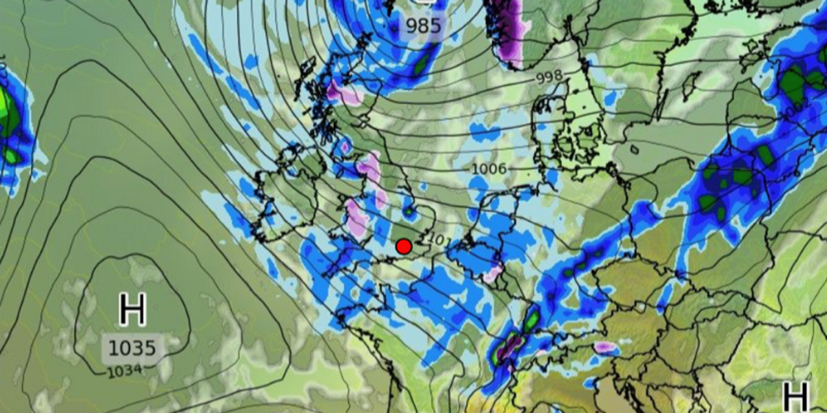
High pressure to the south pushes lows to the north
WX Charts
Low pressure ‘battling’ high pressure will drive the sudden change in weather at the end of the week.
The Azores High–a semi-permanent region of high pressure that brings hot temperatures in the summer–will stretch northwards to the UK.
It will nudge southerly low pressure, which has encouraged mild air in from the south, northwards.
Low-pressure systems arriving from the Atlantic later this week will bounce northwards off the high, encouraging northerly winds.
A rapid fall in temperatures will bring the risk of frost to rural areas, sparking warnings for gardeners to take in tender plants, Dale added.
WEATHER LATEST:
He said: “Gardeners need to beware that the risk of frosts is definitely not over, and that poses a risk for tender plants and crops.
“This is a typical battle ground between high and low pressure and air masses, with the Azores high to the south and lows now passing to the north.
“We are now in a transition zone between the two.”
Meanwhile, temperatures through the start of the week could hit the high-teens in parts of the country.
Southern regions will fare best, although the change in weather patterns will bring the risk of heavy downpours.
Colder air sweeps the UK
Netweather
Most places will stay largely dry, though, with the western coast in the firing line for the heaviest showers.
Met Office meteorologist Alex Deakin said: “Later this week it is going to turn a little colder, noticeably across northern England and Scotland.
“By Friday, temperatures across the land will be at or below average, so it starts pretty mild, but it turns colder.
“Initially, low pressure comes up from the southwest, but later in the week they have a slightly different angle of attack, and with the winds coming in from the northwest, that’s why it will turn fresher going into the weekend.”
Falling temperatures could spark a flurry of snow through the end of the month, although this is most likely over high ground.
Bookmaker Coral has reset the odds to 2/1 from 6/1 on a White Easter, which is often more likely than a White Christmas.
Spokesman John Hill said: “With the threat of snow on the horizon this Easter, our betting suggests there is no danger of Easter eggs melting this year.”
Colder weather may, in part, be the result of a third Sudden Stratospheric Warming (SSW) event this season.
SSW is caused by winds in the stratosphere slowing or changing direction, forcing lower, colder air to spill out of the Polar region.
The phenomenon was the driver of the 2018 Beast from the East, although the impacts on the UK this year are expected to be nowhere as severe.
A Met Office spokesperson said: “The impacts of an SSW do not always equate to cold weather.
“We have only seen intermittent drops in temperature around the two SSW events early this winter and typically around 70 per cent of events are associated with a cold snap.”


