


Britain is bracing for the aftermath of a hurricane currently intensifying in the Atlantic Ocean after the Met Office warned its influence will create a period of unsettled weather.
The forecaster has released a map highlighting areas expected to face the brunt of the remnants of the category 4 storm, which is predicted to bring “disruptive rain and wind” starting midweek.
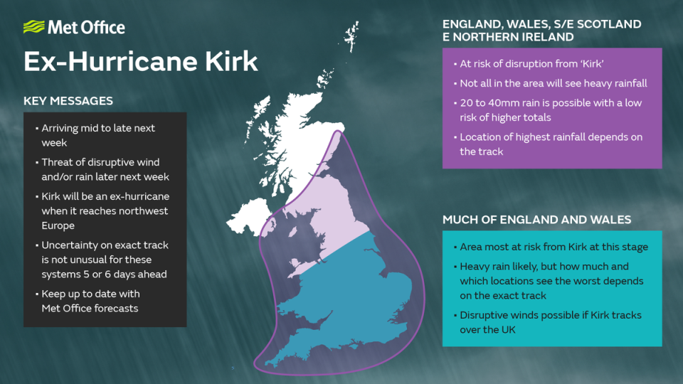
The map shows that the entirety of England and Wales, as well as parts of Northern Ireland, are at risk of disruption from the aftereffects of Kirk. Large parts of Scotland, however, are not predicted to be affected.
In a warning aimed at England, Wales, southeast Scotland and eastern Northern Ireland, the map suggests that between “20 and 40mm of rain is possible”, though it adds that the higher totals are less likely.
England and Wales are predicted to experience the heaviest rain and strongest winds on Wednesday and Thursday, it adds.

Chris Bulmer, deputy chief meteorologist at the Met Office, said: “Kirk over the North Atlantic will lose its status as a hurricane early next week before being swept towards northwest Europe.
“The resulting low-pressure system will still have the potential to bring disruptive rain and winds to some areas, including parts of the UK, from the middle of next week.”
He added while there is still uncertainty about the exact track and timing of the storm, areas of England and Wales are most likely to be affected.
“However, a more southward track of this system, which is equally plausible at this stage, would see the most disruptive conditions impact France,” he said.
“The need for warnings will be kept under review over the coming days, so it’s important to stay up to date with the latest forecast.”
Hurricanes tend to dissipate quickly once temperatures fall below 26.5C, but if Kirk encounters the jet stream it could transform into an extratropical cyclone, potentially causing further issues for the UK.
The coming week might also witness the season’s first snowfall. The Met Office’s long-range forecast suggests snow could fall on the Scottish mountains late next week.
Showers in Scotland and Northern Ireland could turn wintry, and this weather might move south by the weekend, although significant snowfall is not anticipated. Instead, more spells of wind and rain are expected.
Saturday promises fine weather for England and much of Wales, while Northern Ireland and parts of Scotland will see unsettled conditions moving in from the west. Heavy rain is expected to spread eastwards by Saturday evening, easing overnight.
Sunday will bring another band of potentially heavy rain, making for a blustery day with sunny spells and showers. Despite the inclement weather, temperatures will remain mild for October, reaching up to 18C.
As the new week begins, Monday and Tuesday will feature a mix of sunshine and showers, with the heaviest and most frequent showers in the west. The rest of the week is likely to remain unsettled, with the potential for further disruptive rain and wind.


